Source. BBC News
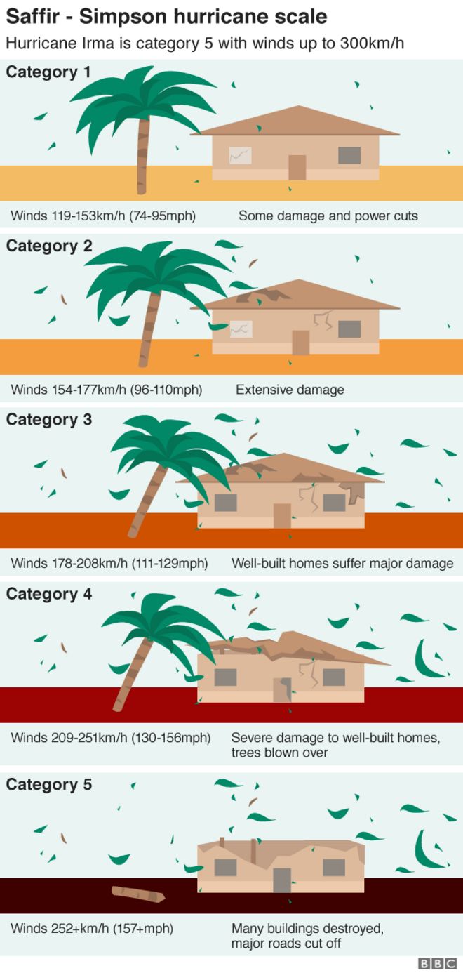
The most powerful Atlantic storm in a decade has caused widespread destruction across the Caribbean and left at least 19 people dead. Irma, a category five hurricane, has been packing winds of up to 295km/h (185mph).
 NOAA GOES-16
Irma has already left the small island of Barbuda "barely habitable" and St Martin almost destroyed. It has also pummelled the Turks and Caicos Islands.
Officials in Florida in the US, where Irma is heading, have warned the storm will "devastate" either Florida or neighbouring states.

Irma is breaking weather records
At its peak, Irma had winds topping 295km/h - making it the strongest storm on record in the Atlantic Ocean, outside of the Caribbean and Gulf of Mexico.
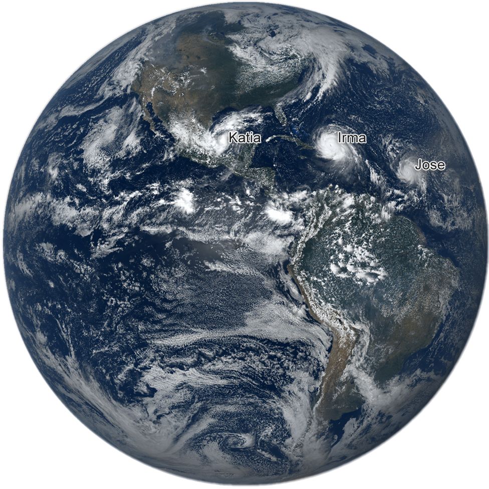
Hurricanes Irma and Jose, 7 September
 NOAA/GETTY IMAGES
According to Phil Klotzbach, research scientist at Colorado State University's Department of Atmospheric Science, Irma's top wind speeds were tied with the second-strongest maximum winds of all time for an Atlantic hurricane. Irma matches a 1935 storm in the Florida Keys and Hurricane Gilbert in 1988 and Wilma in 2005.
Only one hurricane, Allen in 1980, has recorded stronger winds, at 190 mph, he said.
However, Irma has broken Allen's record for sustained winds. It has maintained maximum wind speeds of 295km/h for longer than any other Atlantic Hurricane.
The hurricane's winds have moderated slightly, however, at up to 165mph (270km/h).
Irma grew in strength over a few days
The remnants of Hurricane Harvey, which hit in late August, could still be seen by satellite when Irma made its way across the Atlantic towards the Caribbean.
Irma and remnants of Hurricane Harvey, 2 September
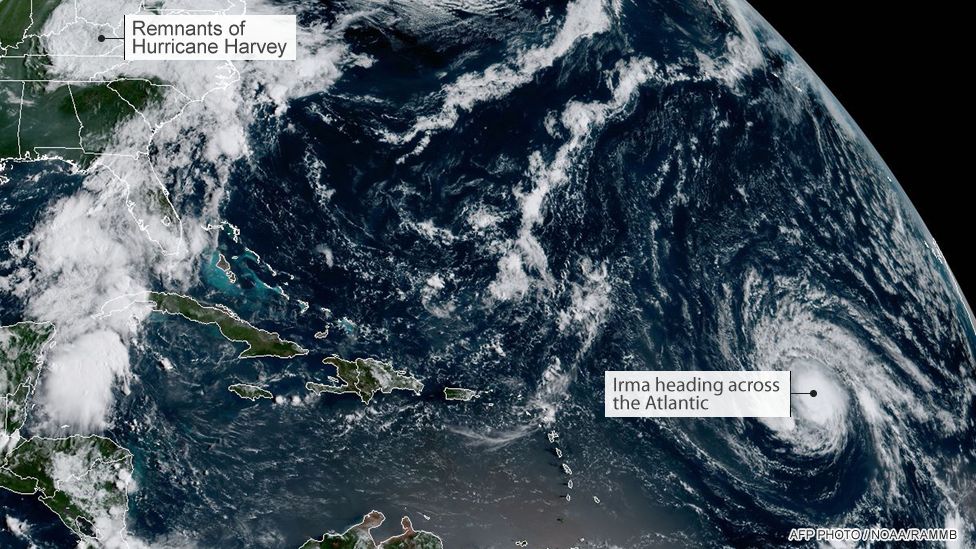
Irma was just a category two storm seen here on 2 September, but soon became category three.
Irma grew stronger quickly because of a combination of very warm water, high levels of mid-level relative humidity, and vertical wind conditions, meteorologists say.
Between 2 and 5 September Irma strengthened from a category three to a category five storm, the highest possible level.
By 6 September, the hurricane was bearing down on the Caribbean, battering many island communities. It continued its trail of destruction through 7 and 8 September.
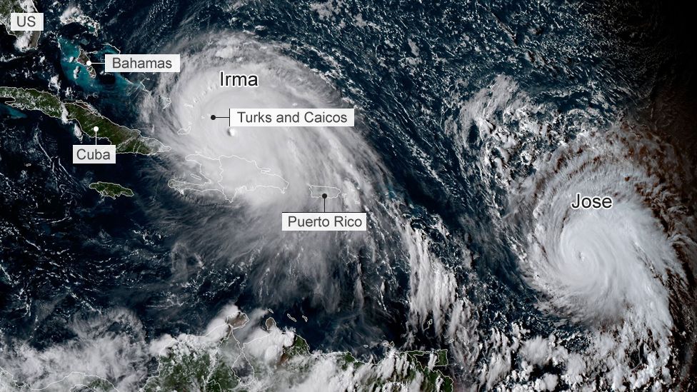
Irma is being followed by storm Jose, which has been upgraded to hurricane status.

Irma's clouds are very, very cold
Infrared data from the Nasa-National Oceanic and Atmospheric Administration's Suomi NPP satellite on 7 September revealed very cold, very high, powerful thunderstorms stretching around Irma's northern, eastern and southern sides.
Storms with cloud tops reaching very low temperatures have the capability to generate "very heavy rainfall", according to Nasa.
Infrared image of Irma, 7 September
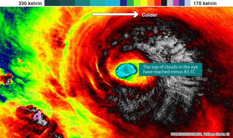
Cloud-top temperatures at the centre of the storm were as cold as 190 kelvin (minus 83.1C/117.7F), Nasa said.
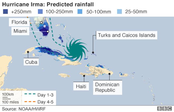
Irma is generating a lot of rain
The eye of the storm is about 35 miles across and is generating "extreme rainfall".
Nasa rainfall analysis of Irma's eye, 5 September
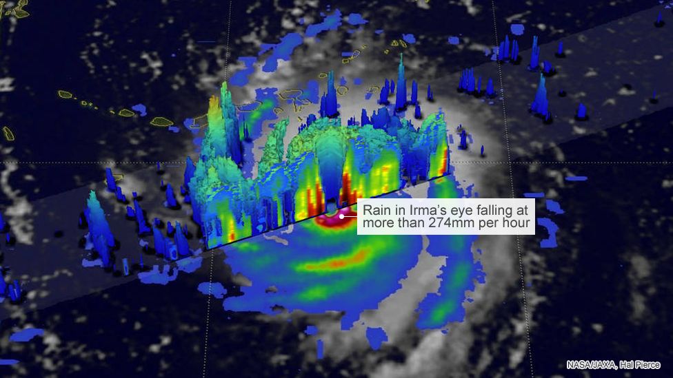
Nasa's rainfall analysis showed rain falling at a rate of more than 274mm (10.8in) per hour on 5 September in the solid ring of storms within Irma's eye.
The powerful storms rotating around the eye were really tall, reaching altitudes greater than 12.5km (7.75 miles).
But the tallest thunderstorms were found south west of Irma's eye, reaching heights of more than 16.2km (10 miles), Nasa said.
Sea temperatures below Irma are warm
Warm oceans, along with wind speed and direction, are the two key ingredients that fuel and sustain hurricanes.
As Irma approaches the Bahamas and Florida, it will be passing over waters that are warmer than 30C (86F) - hot enough to sustain a category five storm, according to Nasa scientists.
Atlantic Ocean, Caribbean Sea, and Gulf of Mexico temperatures
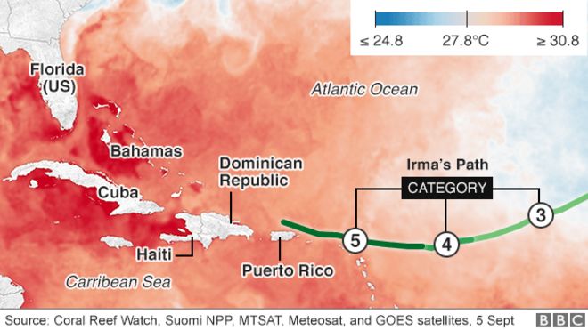
The line on the map represents Irma's track between 3 and 6 September.
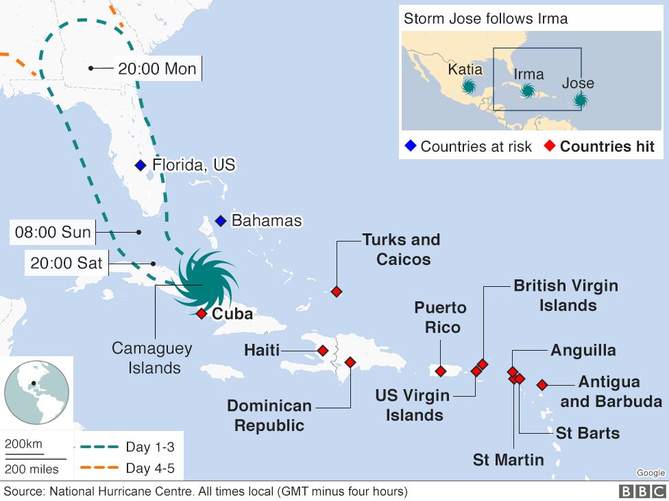
Irma is affecting many places
Hurricane Irma has hit many of the Caribbean's islands and is expected to reach the US on Sunday.
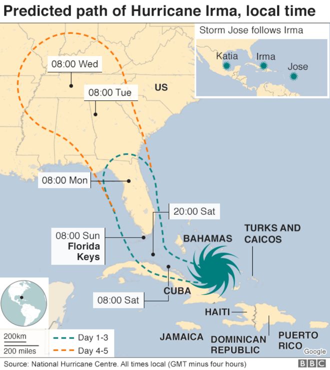
Already hit:
- Antigua and Barbuda
- St Martin
- St Barts (Saint Barthélemy)
- Anguilla
- British Virgin Islands
- Puerto Rico
- Dominican Republic
- Haiti
- Turks and Caicos
At risk:
- Cuba
- Bahamas
- Florida, US
Storm Jose has formed further out in the Atlantic behind Irma, and has been upgraded to hurricane status.
And storm Katia, in the Gulf of Mexico, has also been upgraded. A warning was in effect for the coast of the Mexican state of Veracruz.
The impact could be 'catastrophic'
The howling winds and rough seas of Irma are expected to cause widespread devastation.
The National Hurricane Center says Irma will bring "life-threatening" winds, storm surges and rainfall.

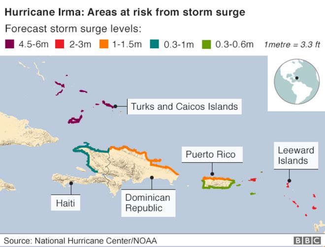
Storm surge risk
Another deadly risk from hurricanes comes in the form of storm surges.
Huge volumes of water are pushed by hurricane force winds. Where they meet land, the water surges inshore at levels far exceeding normal tides.
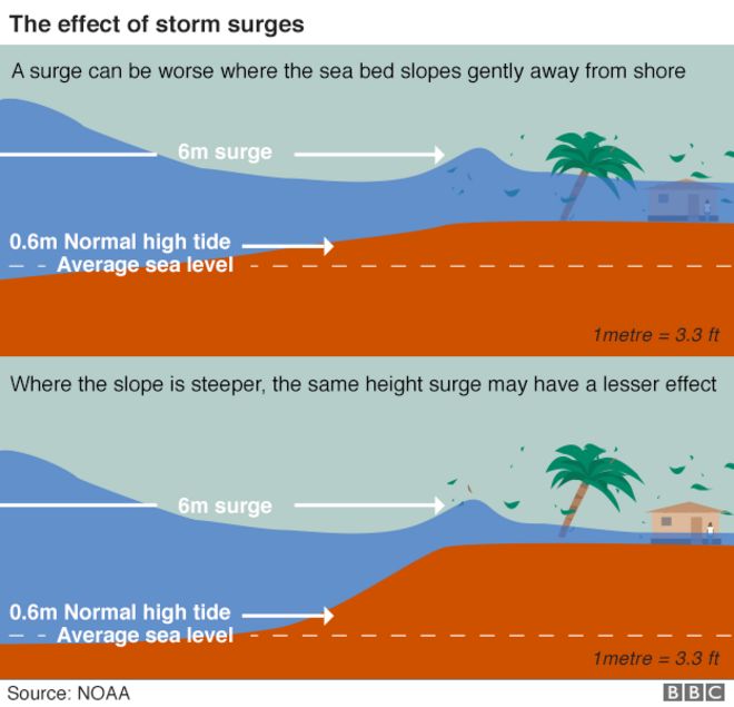
The National Hurricane Center issued warnings for possible storm surges raising water levels from between 30-90cm (3-5ft) in northern Haiti and the northern Dominican Republic to between 4.5-6m (15-20ft) in the south-eastern Bahamas and Turks and Caicos Islands.